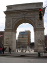
 1. Starting at the Arch in Washington Square Park we will have a brief discussion of the Urban Renewal program and Landmark Preservation movement. If you scroll up and look at the top pictures you will see the rendering of the Urban Renewal Plan, which was created to remove the "blight" from the neighborhood. How did local politics come into play? 1. Starting at the Arch in Washington Square Park we will have a brief discussion of the Urban Renewal program and Landmark Preservation movement. If you scroll up and look at the top pictures you will see the rendering of the Urban Renewal Plan, which was created to remove the "blight" from the neighborhood. How did local politics come into play?
|
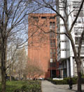
 2. This was the Philip Johnson Master plan which was proposed before Bobst was constructed. Bobst was to be the prototypical building of 150 feet high and made of red sandstone. Do you know what happened to the sandstone quarry? 2. This was the Philip Johnson Master plan which was proposed before Bobst was constructed. Bobst was to be the prototypical building of 150 feet high and made of red sandstone. Do you know what happened to the sandstone quarry?
|
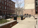
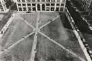 3. This was the vacant lot after the former structures were demolished where Bobst now sits. Can you see why the community was a bit perturbed about Bobst's lack of open space? 3. This was the vacant lot after the former structures were demolished where Bobst now sits. Can you see why the community was a bit perturbed about Bobst's lack of open space?
|
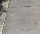 4. We will then carefully cross the street to walk on the recreated bluestone sidewalk, which came into existence out of a Landmarks Preservation controversy. Can you tell which flags are new and which are original? 4. We will then carefully cross the street to walk on the recreated bluestone sidewalk, which came into existence out of a Landmarks Preservation controversy. Can you tell which flags are new and which are original?
|
 5. Walking around the corner we will go through the privately owned street called Washington Mews and discuss its history. 5. Walking around the corner we will go through the privately owned street called Washington Mews and discuss its history.
|
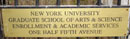 6. When we approach Fifth Avenue we will discuss the creation of the address 1/2 Fifth Avenue and will view the Kimmel Building from the north. Do you know why the address of 1/2 was chosen? 6. When we approach Fifth Avenue we will discuss the creation of the address 1/2 Fifth Avenue and will view the Kimmel Building from the north. Do you know why the address of 1/2 was chosen?
|
 7. Why is this house different from all of the other rowhouses? Why is this door painted green? 7. Why is this house different from all of the other rowhouses? Why is this door painted green?
|
 8. Why is the balustrade beige and the cornice black? Why isn't it the same colors as Goddard Hall, namely beige and red? 8. Why is the balustrade beige and the cornice black? Why isn't it the same colors as Goddard Hall, namely beige and red?
|
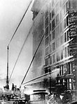 9. HISTORICAL NOTE: On March 25, 1911 the Asche Building had the Triangle Shirtwaist Factory fire. 9. HISTORICAL NOTE: On March 25, 1911 the Asche Building had the Triangle Shirtwaist Factory fire.
|
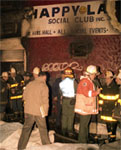 10. HISTORICAL NOTE: On March 25, 1990 the Happyland Fire in the Bronx occurred. How did both fires affect NYU's real estate portfolio? 10. HISTORICAL NOTE: On March 25, 1990 the Happyland Fire in the Bronx occurred. How did both fires affect NYU's real estate portfolio?
|
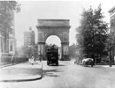
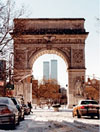 11. This is a view of the Arch when Loeb Student Center was still standing, when the trees covered Loeb and when the camera is not tilted. 11. This is a view of the Arch when Loeb Student Center was still standing, when the trees covered Loeb and when the camera is not tilted.
|
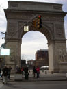  12. This is the view after the Kimmel Center was completed. As you can see, it depends on how you tilt your camera to show if Kimmel is in the view or not. If you scroll up to picture No. 1, you can see the view before Loeb was even built; and the warehouse behind Loeb was still visible. 12. This is the view after the Kimmel Center was completed. As you can see, it depends on how you tilt your camera to show if Kimmel is in the view or not. If you scroll up to picture No. 1, you can see the view before Loeb was even built; and the warehouse behind Loeb was still visible.
|
 13. We will continue west on Washington Square North and then south on Washington Square West.Which plaque received a Landmarks Preservation Violation for not being filed when it was installed by a civic group? 13. We will continue west on Washington Square North and then south on Washington Square West.Which plaque received a Landmarks Preservation Violation for not being filed when it was installed by a civic group?
|
 14. We will leave the Greenwich Village Historic District and walk on MacDougal Street and pass the former Provincetown Playhouse site. 14. We will leave the Greenwich Village Historic District and walk on MacDougal Street and pass the former Provincetown Playhouse site.
|
 15. Continuing our walk, we will pass the 3 houses which were once the "poster child" of the Urban Renewal plan, depicting the blight. 15. Continuing our walk, we will pass the 3 houses which were once the "poster child" of the Urban Renewal plan, depicting the blight.
|
 16. The same 3 houses are currently protected by the Landmarks Preservation Commission. 16. The same 3 houses are currently protected by the Landmarks Preservation Commission.
|
 17. Do you know why Bobst sticks out so far to the west on LaGuardia Place? Do you know why it is now called LaGuardia Place and not West Broadway or Lower Fifth Avenue? 17. Do you know why Bobst sticks out so far to the west on LaGuardia Place? Do you know why it is now called LaGuardia Place and not West Broadway or Lower Fifth Avenue?
|
 18. Do you know where the open space and FAR went to for this garden space? What is underneath the street? 18. Do you know where the open space and FAR went to for this garden space? What is underneath the street?
|
 19. Walking eastward on West Third Street we will discuss the former Elevated Subway line. Do you know where the Poe House actually was situated before it's facade was incorporated into Furman Hall? 19. Walking eastward on West Third Street we will discuss the former Elevated Subway line. Do you know where the Poe House actually was situated before it's facade was incorporated into Furman Hall?
|
 20. We go south on La Guardia Place discussing the whole issue of Robert Moses and Mayor LaGuardia. We will then walk through the residential portion of the Urban Renewal plan, staying on the former street grid. 20. We go south on La Guardia Place discussing the whole issue of Robert Moses and Mayor LaGuardia. We will then walk through the residential portion of the Urban Renewal plan, staying on the former street grid.
|
 21. The retail area of the Urban Renewal Plan (with a commercial overlay) once housed the Martin Luther King Center African-American Student Center. 21. The retail area of the Urban Renewal Plan (with a commercial overlay) once housed the Martin Luther King Center African-American Student Center.
|
 22. The interior open space of Washington Square Village was not open to the public or even to NYU affiliates. Do you know who was permitted to use the elevated park? It is now open to the public. 22. The interior open space of Washington Square Village was not open to the public or even to NYU affiliates. Do you know who was permitted to use the elevated park? It is now open to the public.
|
 23. We then cross Bleecker Street and walk through the I. M. Pei superblock and discuss the lawsuit by Edward I. Koch and the creation of the third tower for community residents. Do you think that Picasso was the artist of the large Sylvette sculpture or could it be some Norwegian artist? 23. We then cross Bleecker Street and walk through the I. M. Pei superblock and discuss the lawsuit by Edward I. Koch and the creation of the third tower for community residents. Do you think that Picasso was the artist of the large Sylvette sculpture or could it be some Norwegian artist?
|
 24. The tour ends up on Houston Street walking back to the Puck Building. We will pass another lawsuit dealing with who owns public artwork that is installed on the side of a commercial condo within a Historic District. Do you know who owns the public artwork that is affixed to buildings? Is it the condo, the artist or the city? 24. The tour ends up on Houston Street walking back to the Puck Building. We will pass another lawsuit dealing with who owns public artwork that is installed on the side of a commercial condo within a Historic District. Do you know who owns the public artwork that is affixed to buildings? Is it the condo, the artist or the city?
|
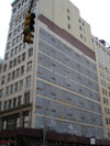
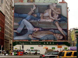 25. Is this obscene? How does the First Amendment of the U.S. Constitution affect land use law when it comes to public advertising signs and the regulations that control them? The First Amendment also comes into play with religious land use issues, such as Crosses on public lands, and steeple heights, etc. 25. Is this obscene? How does the First Amendment of the U.S. Constitution affect land use law when it comes to public advertising signs and the regulations that control them? The First Amendment also comes into play with religious land use issues, such as Crosses on public lands, and steeple heights, etc.
|
Useful Information:
Click Here to see the NYC Zoning Map for the area around NYU.
Click Here to see the Landmarks Preservation Designation Report for the NYU block of Silver Towers (Block 524).
Most of the area is in the R7-2 Zoning District, which permits residential and community facility (university) uses as-of-right, with a maximum residential FAR of 3.44 and a Community Facility (or mixed building) FAR of 6.5. Part of the area is covered with special Urban Renewal restrictions and covenants.
|


 This tour is given by Rick Landman, a land use professor and attorney and former Chair of the Landmarks Committee, Planning Committee and Tribeca Committee of Community Board #1 Manhattan. He is a Native New Yorker who was born under Mayor Impellitteri's term when Truman was president. That was before Brown v. Bd of Education and the various Civil Rights laws during the mid 1960's. He was part of the "bussing" guinea pig students to end segregation in the NYC Public Schools. He grew up in NYC when "separate but equal" was the law of the land in both private and public housing. He also worked for NYU for almost 20 years as an administrator and adjunct professor. Many of his stories about the subject are from first hand memories.
  ABOUT THE TOUR GUIDE
 NY Metro Chapter, 2011 Autumn Walking Tours